Earaheedy Project – Western Australia.
EARAHEEDY TENEMENT E 38/3624
The Earaheedy licence is located approximately 200km east of Wiluna and 220km southeast of the RTR Chinook and Magazine Pb-Zn discoveries, having been pegged by Unconformity Zinc Pty Ltd (UZ) in 2021 along strike from Rumble Resource’s (RTR’s) position in the basin.
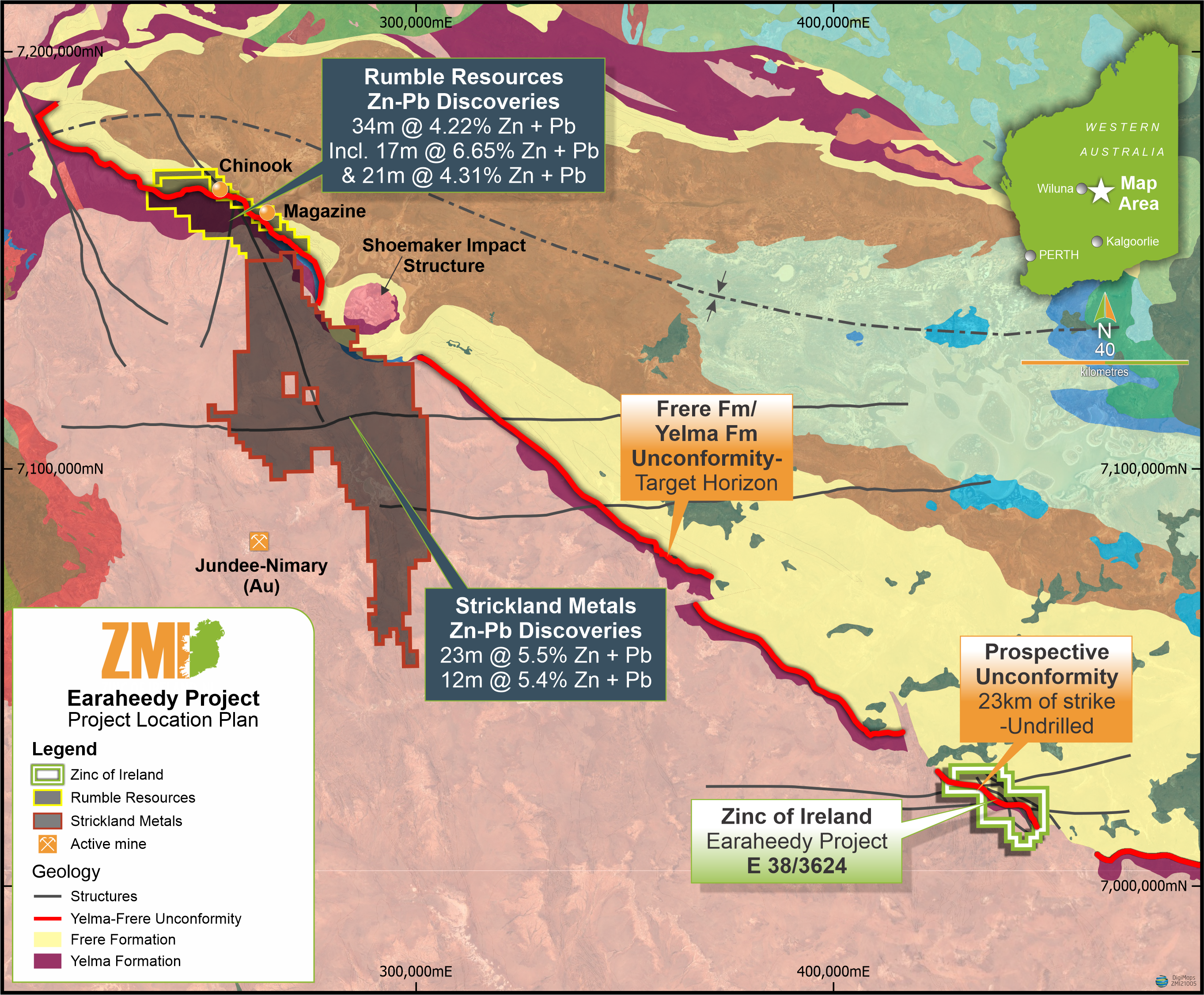
Zinc of Ireland tenement with respect to unconformity contact and Rumble Resources and Strickland Metals discoveries.
EARAHEEDY PROJECT - GEOLOGY
The ZMI tenement is largely unexplored with previous operators having focused on gold within Archean greenstones adjacent to the tenement and under Proterozoic cover, especially to the west of the Licence area. A wide-spaced State geochemistry programme has returned a 181ppm Zn result (WACHEM dataset Sample ID 166818_C1M3SD3) coincident with the Frere/Yelma unconformity.
The licence contains approximately 23km of strike of the target unconformity between the Frere and Yelma formations. The Paleoproterozoic Frere Formation is comprised of granular iron-formation, granular siliceous iron-formation, peloidal chert, siltstone and sandstone and unconformably overlies sandstones, siltstones, shales, minor conglomerates and dolomite of the older Yelma Formation.
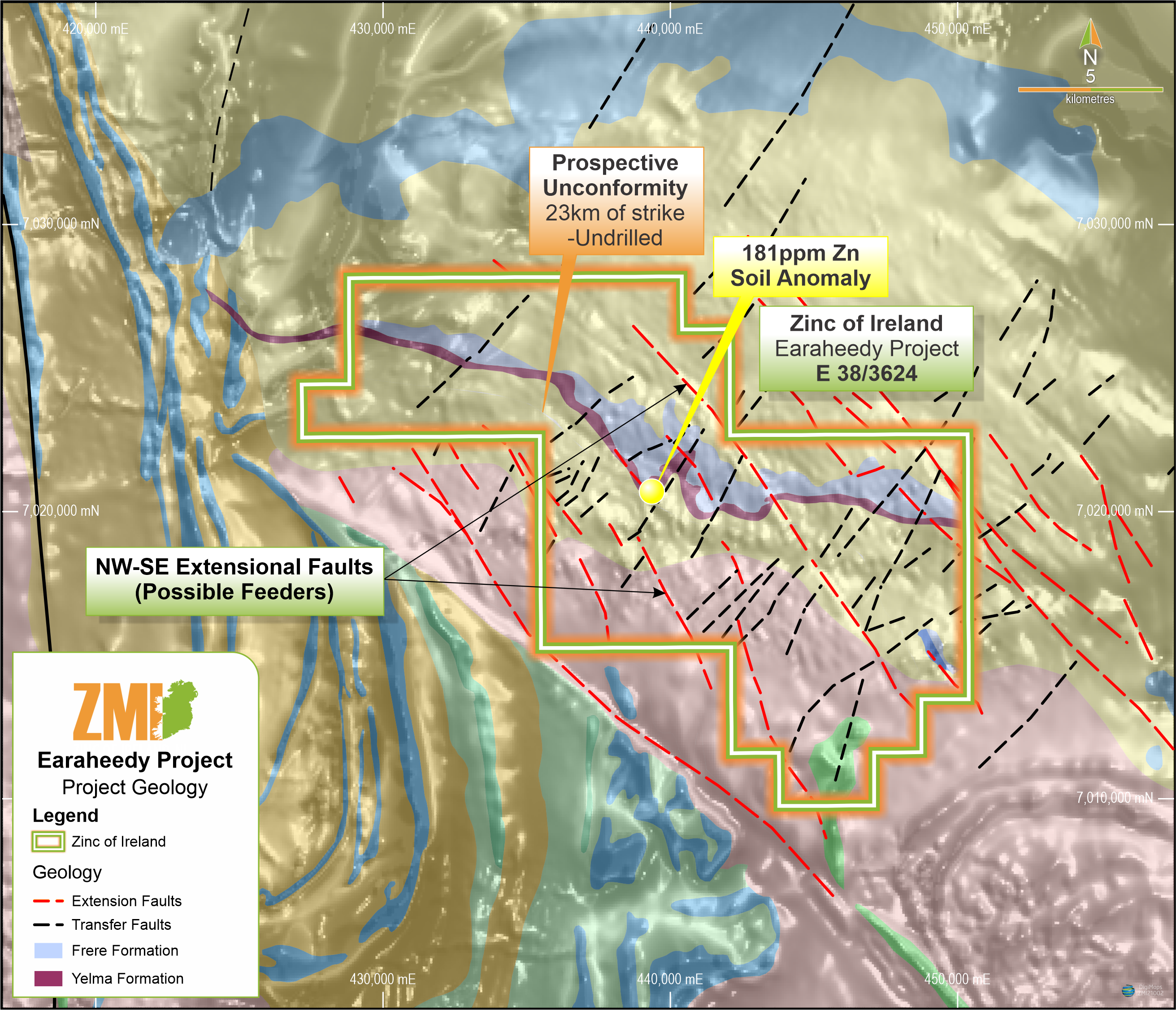
Tenement location containing 23km of prospective unconformity striking northwest with anomalous soil sample at the contact. (WACHEM dataset, 181ppm Zn Sample ID 166818_C1M3SD3).
ZMI considers the EL to be prospective for sedimentary exhalative (SEDEX) zinc lead mineralization and amenable to low-cost geochemical exploration techniques along the unconformable contact.
The Zn-Pb mineralization identified at Chinook and Magazine is reported to occur as sphalerite galena and pyrite hosted within sandstone subbasins overlying the Frere/Yelma unconformity (refer BPM Minerals (ASX:BPM) announcement dated 19 May 2021).
Previous ground based exploration on the tenement appears to be negligible based on a search of open source data. Airborne magnetic and radiometric data was collected by North Ltd in 1996 (WAMEX openfile Ref: A52845) providing coverage of approximately two thirds of the tenement including all of the unconformable contact target area. A similar structural regime proposed by North Ltd is also apparent in the government aeromagnetic dataset and has obvious similarities to that depicted on the RTR tenements where the NNW-SSE and ENE-WSW structures are readily apparent, the former appearing to bisect the tenement.
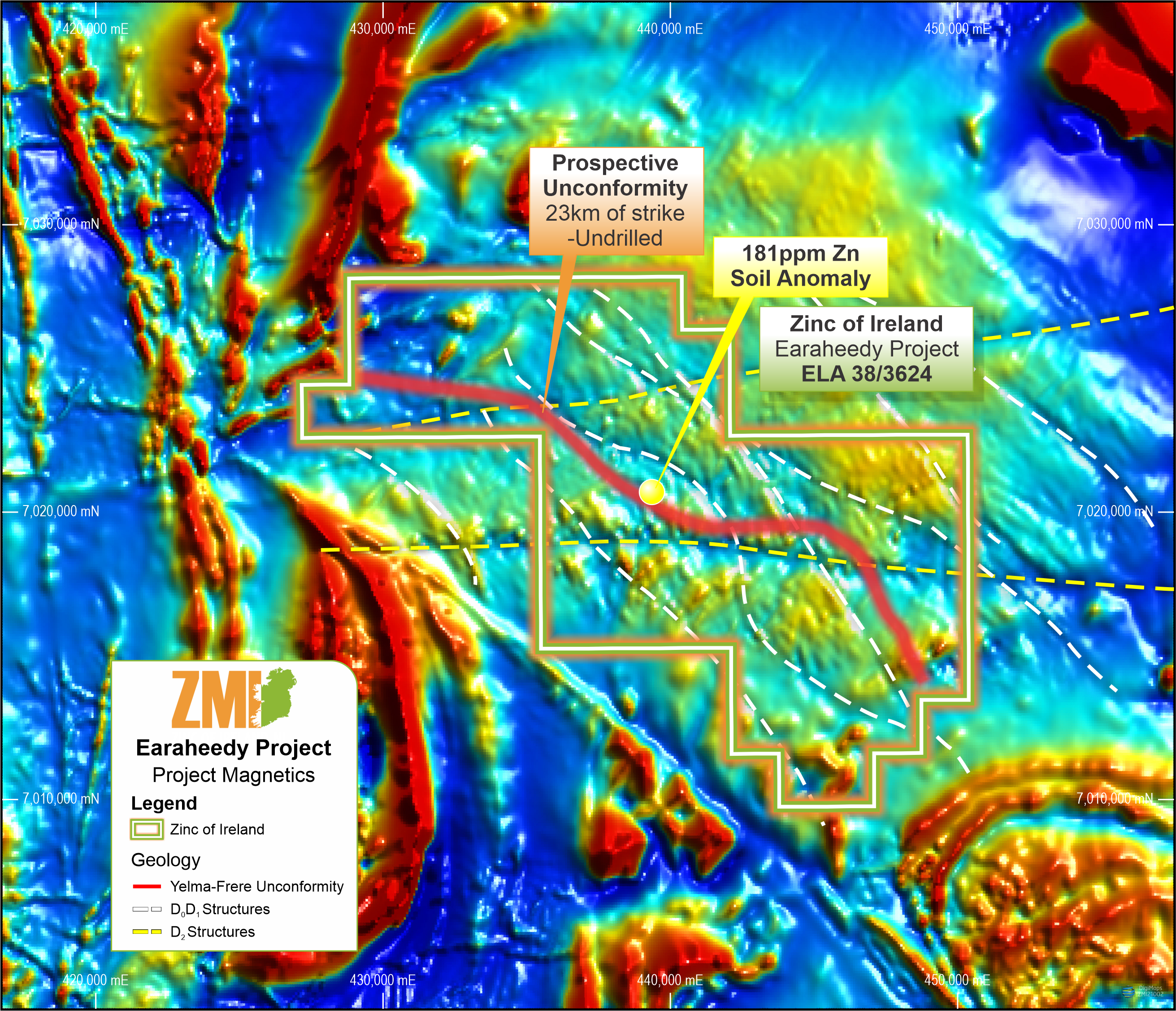
Wamex Open Source Aeromagnetic data (TMI) with strongly developed structural sets.
INITIAL SITE VISIT
The proposed initial work programme aims were comprised of:
- Assessment of surficial cover and the amenability of surface geochemistry along the unconformity.
- Reconnaissance mapping to better delineate the iron rich Frere Formation’s unconformable contact with the underlying Yelma Formation and to understand the project regolith and types of cover and the most appropriate geochemical sampling technique’s going forward.
- Visiting the site of the anomalous surface sample recorded in WA GeoView database (181ppm Zn).
- Trial portable XRF (pXRF) lines across unconformity looking for base metals (Zn in particular).
INITIAL SITE VISIT OUTCOMES
The Company’s consultants were able to successfully implement the majority of the designed programme goals.
- Approximately half of the inferred contact zone strike length was visited, however heavy rainfall and initial access difficulties resulted in the curtailment of the reconnaissance of the western portion of the EL.
- Orientation soil samples were collected with results pending.
- Access options were explored and recommendations for future visits made.
PROPOSED WORK PROGRAMME – 2022
The proposed work programme to be carried out will be guided by the results of the initial site visit which are still pending for interpretation. The likely components are:
- The western portion of the 23km long unconformity corridor will be pXRF sampled to complete the aims of the initial field visit.
- pXRF and/or soil anomalism identified in 2021 will be infill sampled and mapped in greater detail.
- Anomalous areas will be targeted with conventional soil geochemistry and/or power auger sampling as appropriate.
- Ground geophysical surveys may be carried out to follow up on or supplement areas identified by first pass mapping and sampling.
- Drill planning and permitting.
The absence of previous exploration data (with the exception of sparse broadly spaced, circa 2km by 2km, soil geochemistry) in combination with readily available open source data and the current and ongoing success of other exploration companies along strike in 2021 continues to lend itself towards the implementation of simple, cost effective exploration strategies at ZMI’s Earaheedy licence. The Company remains optimistic that current pandemic driven personnel and equipment shortages will ease during 2022 increasing ZMI’s ability to carry out accelerated exploration at Earaheedy.